Feb 272013
 

Introduction :
The Puerto Princesa River National Park is located in Philippines, Palawan island province and is 50 km north of the city of Puerto Princesa. The national park falls under the Saint Paul mountain range if the island and is famous for its spectacular limestone landscape and underground river beneath. The Puerto Princesa River National Park is one of the New7Wonders of Nature chosen in a global pool in 2012 and is also a World Heritage Site since 1999 for their limestone landscape and mountain to sea eco system. The area of the heritage site is around 57 square km and contains a long 8.2 km underground river and flows directly into the South China Sea with a scenic yet unique cave view.

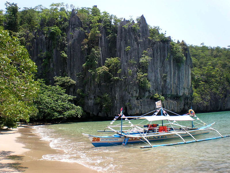
Docking area to get to the underground river
Image attribution to Matikas_0805 @ Wiki

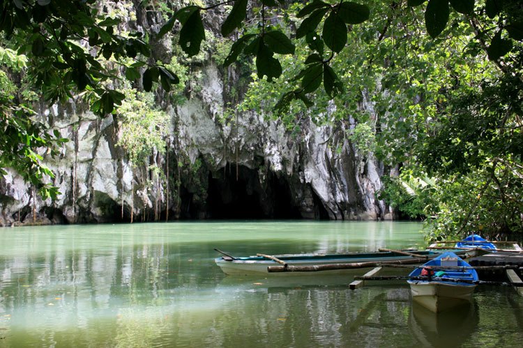
Entrance into the underground river

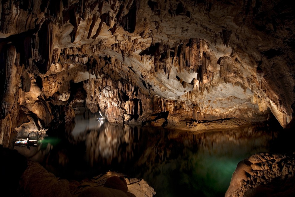
Incredible and unique view of the cave river

History :
The geography features in the Puerto Princesa River National Park was believed to have been formed 16-20 million years ago. The earliest documentation of the underground river was in 1887 by American professor of Zoology, Deanc C, worcester that the area is a lake opening to the sea by a Subterranean River. The national park was established in 1971 by President Ferdinand E. Marcos and expanded the area to 220 square km and was declared as a National Geological Monument in 2003.

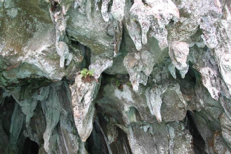
Closer look at the top of the caves
Image attribution to Paul Chin @ Wiki

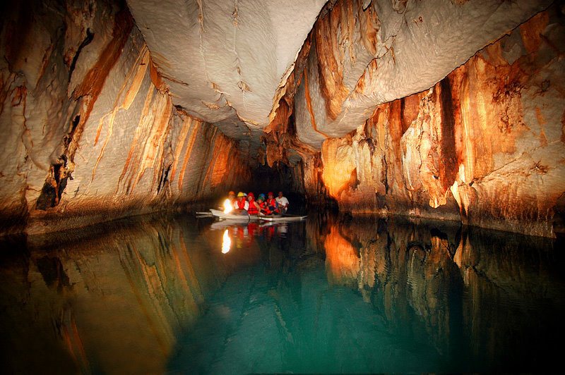
Canoeing is the only way to travel the underground river

Getting there :
The nearest airport to the destination is the Puerto Princesa International Airport (PPS) serving the city center of Puerto Princesa. The airport is mainly served by flights from the capital city of Philipines in Manila.

Feb 262013
 

The Acropolis of Athens is situated in the rocky area above the capital city of Athens in the Attica region of Greece. The Arcopolis in Athens is an ancient citadel and is the most famous of all acropolis in the world and contains the remains of ancient buildings with great historical and cultural significance including one of the most important buildings in the ancient world, the Parthenon. Due to its rich archaeological importance, it became a World Heritage Site in 1987 and was also one of the most important momuments on the European Cultural Heritage lists. The main archaelogical remains the Acropolis of Athens are the Parthenon, the Old Temple of Athena, Erechtheum, Propylaea, Statue of Athena and more.

A look into the interior court
Overview of the Acropolis of Athens
Image attribution to Christophe Meneboeuf @ Wiki

Propylaea is a monumental gateway that serves as the entrance to the Acropolis of Athens
Image attribution to stacylynn @ Flickr

The famous Parthenon is one of the most important building in Greek history
Image attribution to Richardsonpilot @ Flickr

History :
Archaelogical evidence from small caves points out that the Acropolis rock area were inhabited as early as 3000 BC and the Myceanae civilization established palaces in the site in around 1400 BC but were destroyed by invading Greek troops from mainland Greece and were left with little remains today. The Old temple of Athena was one of the oldest remains in the area and was built around 529 BC while the construction of the Parthenon started as early as 500 BC with the rest of the building remains estimated to be building during the period of 480 to 406 BC. The buildings were repaired during the Romans period before The Acropolis of Athens was used by the Byzantines as an adminstrative center in the city. A restoration project began since 1975 aimed to restore the decay in centuries of pollution and wartime destruction.

The Acropolis of Athena during night time
Image attribution to ellie-yannis @ Flickr

Close up at the Old Temple of Athena
Image attribution to shelbyroot @ Flickr

The Theatre of Dionysis
Image attribution to zsenya @ Flickr

Caryatid sculpture at Erechtheion
Image attribution to profzucker @ Flickr

Getting there :
The nearest airport to the Acropolis of Athens is the Athens International Airport and is just 1 hour or lesser by taxi or metro (railway) to the Acropolis.

Feb 252013
 

Introduction :
Jeju Island is part of South Korea and has been assigned as a Special Self-Governing Province within the country and lies in the Korean Strait, southwest of the South Jeolla Province. The island has a population of 590, 000 and measures 1849 square km in total area making it the largest island in South Korea. Jeju island is famous for its volcanic sceneries and lava tubes which are both UNESCO World Heritage Sites as well as natural heritages within the island. Mount Halla located within the island also has the highest point in the country. The island is also sometimes known as Jeju-do or Cheju to Europeans.

Aerial view of the island with the volcano crater

The beautiful coast at the island
Image attribution to Isageum @ Wiki

The Yakcheonsa Temple
Image attribution to lt @ Wiki

Some attractions :
Mount Halla – Also known as Hallasan, this mountain is the highest point of South Korea and is also a massive shield which takes up large parts of the island and can be seen from most parts of the island. Situated within it are beautiful waterfalls and a lake filled crater creating a site of outstanding natural beauty.

Geomunoreum lava tubes – A series of Lava tube caves formed between 100-300 thousand years ago and widely regardly as the finest lava cave system in the world with beautiful internal scenery.

Jeju Mysterious Road – A short stretch of road that gives you an impression you’re travelling against gravity

Cheonjiyeon Waterfall – The most famous and scenic waterfall in the island

Yeomiji Botanic Gardens – More than 3000 species of plants and flowers in an indoor environment of 1120 square metres, it was described as one of the best botanic gardens in Asia.

Green tea museum – Museum built in the shape of a tea cup.

Cheonjiyeon Waterfall

Crater lake at the top of Mount Halla
Image attribution to Mass ave 975 @ Wiki

Tea Museum in the island
Image attribution to lt @ Wiki

History :
The kingdom of Tamna ruled Jeju Island during the ancient times with no proof of time line yet and remain solitary until it came under the Korean Joseon Dynasty in 1404. Legends has it that the ancestors of the Jeju people descended on the northern slopes of Mount Halla and founded the Kingdom of Tamna.

Toilet for the PIGS in Jeju
Toilet for the Pigs in Jeju
Image attribution to Hhaithait @ Wiki

Dol Hareubang statues around the Jeju Island
Image attribution to lt @ Wiki

Getting there :
The nearest airport to Jeju Island is the Jeju International Airport (CJU) and serves international destinations such as China, Japan and Taiwan as well as domestic flights from the mainland.