Mar 282013
 

Introduction :
The Denali National Park is located in the state of Alaska in USA covered by the Denali Borough and the Matanuska-Susitna Borough. The Denali National Park measures a massive area of 19,185 square km and is home to Mount Mckinley which is the third highest peak in the world with an elevation of 6194 metres. The attractions in the national park are the beautiful alpine lakes and forests in the lower elevations, tundra in the mid points and glaciers, rock and snow at the highest elevations. The Denali National Park is host to more than 400,000 visitors annually and is a great place for sceneries, hiking and mountaineering in the pure and untamed wilderness of Alaska.

Alpine forests and lakes at the lower elevations

A full view of Mount McKinley
Image attribution to crosby_cj @ Flickr

The Dall sheep plays an important role in the establishment of the park

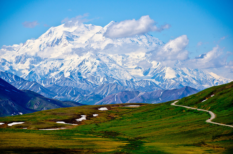
Road towards the 3rd highest peak of the world
Image attribution to Unhindered by Talent @ Flickr

History :
Native Americans were living in the environment since 11,000 years ago using resources the wild provided. In 1907, hunter and naturalist Charles Sheldon took interest in the area and specifically on the Dall sheep and traveled to the region. He returned to Washington and helped to establish the Mount Kinley National Park in 1917. In 1976, President Jimmy Carter designated the park as an international biosphere reserve and finally in 1980, the Denali National Park was formed with the incorporation of the Denali National Monument.

The Grizzly Bear of Denali
Image attribution to Fir0002 @ Flickr

Rare sighting of a double rainbow Panorama
Image attribution to granteaton @ Flickr

The Wonder Lake is the result of glacier erosion and ice block melting
Image attribution to BillC @ Wiki

The summit of Mount Mckinly at elevations of over 6000 metres
The summit of Mount Mckinley at elevations of over 6000 metres

Getting there :
The nearest airport to the Denali National Park would be the Fairbanks International Airports (FAI) which requires a 2 hour drive to the attraction. The nearest major airport would be the Ted Stevens Anchorage International Airport (ANC) which is a 5 hour drive to the attraction. Most of the flights available are on a seasonal basis.

Mar 272013
 

Introduction :
The Shwedagon Pagoda is the iconic landmark and spiritual center of the capital city of Yangon in Myanmar. Sitting on top of the Singuttara Hill, the Shwedagon Pagoda dominates the skyline of the city and is considered the most sacred Buddist Pagoda in the country with relics of four Buddha enshrined within. They are the Staff of Kakusandha, the water filter of Konagamana, Robe piece of Kassapa and eight strands of hair from Gautama.

Viewing the Shwedagon Pagoda from outside
Image attribution to bessieandkyle @ Flickr

In and walking around the area
Image attribution to bessieandkyle @ Flickr

Evening time
Evening time
Image attribution to phonks @ Flickr

Human lion sculpture around the Pagoda
Image attribution to Lionslayer @ Wiki

History :
According to legends the Shwedagon Pagoda has existed for more than 2600 years ago, making it the oldest historical pagoda in Myanmar and all over the world. Historical and archaeological records show that however, the pagoda was built and completed between the 6th and 10th century by the Mon people. Rebuilding took place throughout the years and during the 14th century, the stupa that fell into disrepair was rebuilt to a height of 18 metres while it was raisied to 40 metres a century later. The Shwedagon Pagoda became the most famous place of pilgrimage in the country by the beginning of the 16th century.

One of the shrines in Shwedagon
Image attribution to pwbaker @ Wiki

Famous nightview of the landmark from the city of Yangon
Image attribution to exotissimo @ Flickr

Closer look at the golden pagoda at night
Image attribution to isriya @ Flickr

Offerings at one of the planetary post
Image attribution to Lionslayer @ Wiki

Getting there :
The nearest airport to the Shwedagon Pagoda is the Yangon International Airport from which only requires a 30 min drive to the attraction.

Mar 262013
 

Introduction :
Cinque Terre is a rugged portion of coastline situated in the Liguria region of north-west Italy and comprises of five towns which are Vernazza, Corniglia, Monterrosso, Manarola and Riomaggiore. The Cinque Terre is famous for its landscapes of exceptional scenic quality and represents the harmony between human and mother nature that exists for over a millienium. The five villages, together with the coastline and surrounding hills make up the Cinque Terre National Park and was inscribed as a World Heritage Site by UNESCO in 1997.

The town of Vernazza with its blue waters
Image attribution to chensiyuan @ Wiki

Aerial view of the towns below
Image attribution to wuensch @ Flickr

The Corniglia town is built on the highest landscape in the area
Image attribution to chensiyuan @ Wiki

San Pietro Gothic Church
Image attribution to ghirolfo53 @ Flickr

Evening time in Manarola
Image attribution to chensiyuan @ Wiki

History :
Inhabited since the Bronze Ages, the region has been home to peaceful fisherman and farmers while being constantly pillaged by pirates and slave traders. The first establishments in the region was founded in 1000 AD by the inhabitants living on the Reggio hills and it soon became part of the Republic of Genoa. People began carefully building houses on the rugged landscapes of the Cinque Terre throughout the years to form what is now landscapes. The name of Cinque Terre and the five villages was given during the later Middle Ages as early as the 15th century. The Cinque Terre was largely inaccessible by many until the 1870s when the Genoa-La Spezia railway connected it to land passing through all the villages.

Monterosso town in Cinque Terra
Image attribution to EpicV27 @ Wiki

IL Gigante was once the landmark of Cinque Terra until WW II bombings destroyed one of its hands
Image attribution to wuensch @ Flickr

Following the Red Trail in Cinque Terre
Image attribution to Chuntera @ Flickr

Beautiful sunset of Monterosso as seen from Vernazza
Image attribution to R Alescio @ Flickr

Beautiful sunset of Monterosso as seen from Vernazza
Night time at Cinque Terre
Image attribution to thymeless @ Flickr

Getting there :
The nearest international airport to the Cinque Terra is the Genoa Cristoforo Colombo Airport that serves most major European cities. This is followed by a Volabus bus trip to the main train station in Genoa (BRIGNOLE RAILWAY STATION) where you can take take a train ride to one of the five villages in Cinque Terre, please take note to remember some of the names of the villages (Vernazza, Corniglia, Monterrosso, Manarola and Riomaggiore) for trip information at the train station.