Apr 082013
 

Introduction :
Mont St-Michel is a rocky island and commune in the Normandy region of France. The island is one of the most recognized landmarks in France and has been a strategic place for forticiations since ancient times. Mont St-Michel is a Gothic style Benedictine abbey dedicated to the archangel St Michael and was often mentioned as a Wonder of the West. Together with its bay, the area has been inscribed as a World Heritage Site since as early as 1979 and is today one of the most popular tourist attractions in the region.

Aerial view of Mont St-Michel and its bay

Panorama of the world Heritage Site
Image attribution to joanet @ Flickr

The grasslands and cows at Mont St-Michel
Image attribution to L-98 @ Wiki

Entrance to the abbey
Image attribution to Kamel15 @ Wiki

History :
The bay around Mont St-Michel was land during the prehistoric times and the current landscape was shaped by erosion as the sea levels rose. During the 6th and 7th century, the Mont St Michel was used as a stronghold of Gallo-Roman power under the rule of the Roman Empire until it was ransacked by the Vikings. During the Hundred Years War between England and France, the English made numerous assault on the island but were unable to seize it and the iron bombarbs left by the English during their 1424 siege are still displayed at the outer defense wall of the city. Louis XI of France had intended for the abbey church of Mont St-Michel to be the chapel of Order but was never realized due to its distance from Paris. During the time of the French revolution, the abbey was closed and turned into a prison which held many hih profile political prisoners along the years until it was closed in 1863 and delcared a historic monument of France.

Barrage controlling the tides at Mont St-Michel
Image attribution to Pline @ Wiki

The streets and shops in Mont St-Michel
Image attribution to derrickding @ Flickr

The village houses of Mont St-Michel
Image attribution to Stevage @ Wiki

Beautiful sight at night fall
Image attribution to Benh @ Wiki

Herds of cow taking a stroll on a misty morning just outside Mont St-Michel
Image attribution to Bnacehko @ Wiki

Getting there :
The nearest airport to Mont St-Michel is the Rennes-Saint-Jacques Airport (RNS) which is around 70 km away from the island and serves flights from several major cities from France, Spain and England. From the capital city Paris, the distance to Mont St-Michel is around 4 hours. Visitors are recommended to reach the destination by car as the cheapest, easiest and safest way.

Mar 262013
 

Introduction :
Cinque Terre is a rugged portion of coastline situated in the Liguria region of north-west Italy and comprises of five towns which are Vernazza, Corniglia, Monterrosso, Manarola and Riomaggiore. The Cinque Terre is famous for its landscapes of exceptional scenic quality and represents the harmony between human and mother nature that exists for over a millienium. The five villages, together with the coastline and surrounding hills make up the Cinque Terre National Park and was inscribed as a World Heritage Site by UNESCO in 1997.

The town of Vernazza with its blue waters
Image attribution to chensiyuan @ Wiki

Aerial view of the towns below
Image attribution to wuensch @ Flickr

The Corniglia town is built on the highest landscape in the area
Image attribution to chensiyuan @ Wiki

San Pietro Gothic Church
Image attribution to ghirolfo53 @ Flickr

Evening time in Manarola
Image attribution to chensiyuan @ Wiki

History :
Inhabited since the Bronze Ages, the region has been home to peaceful fisherman and farmers while being constantly pillaged by pirates and slave traders. The first establishments in the region was founded in 1000 AD by the inhabitants living on the Reggio hills and it soon became part of the Republic of Genoa. People began carefully building houses on the rugged landscapes of the Cinque Terre throughout the years to form what is now landscapes. The name of Cinque Terre and the five villages was given during the later Middle Ages as early as the 15th century. The Cinque Terre was largely inaccessible by many until the 1870s when the Genoa-La Spezia railway connected it to land passing through all the villages.

Monterosso town in Cinque Terra
Image attribution to EpicV27 @ Wiki

IL Gigante was once the landmark of Cinque Terra until WW II bombings destroyed one of its hands
Image attribution to wuensch @ Flickr

Following the Red Trail in Cinque Terre
Image attribution to Chuntera @ Flickr

Beautiful sunset of Monterosso as seen from Vernazza
Image attribution to R Alescio @ Flickr

Beautiful sunset of Monterosso as seen from Vernazza
Night time at Cinque Terre
Image attribution to thymeless @ Flickr

Getting there :
The nearest international airport to the Cinque Terra is the Genoa Cristoforo Colombo Airport that serves most major European cities. This is followed by a Volabus bus trip to the main train station in Genoa (BRIGNOLE RAILWAY STATION) where you can take take a train ride to one of the five villages in Cinque Terre, please take note to remember some of the names of the villages (Vernazza, Corniglia, Monterrosso, Manarola and Riomaggiore) for trip information at the train station.

Feb 252013
 

Introduction :
Jeju Island is part of South Korea and has been assigned as a Special Self-Governing Province within the country and lies in the Korean Strait, southwest of the South Jeolla Province. The island has a population of 590, 000 and measures 1849 square km in total area making it the largest island in South Korea. Jeju island is famous for its volcanic sceneries and lava tubes which are both UNESCO World Heritage Sites as well as natural heritages within the island. Mount Halla located within the island also has the highest point in the country. The island is also sometimes known as Jeju-do or Cheju to Europeans.

Aerial view of the island with the volcano crater

The beautiful coast at the island
Image attribution to Isageum @ Wiki

The Yakcheonsa Temple
Image attribution to lt @ Wiki

Some attractions :
Mount Halla – Also known as Hallasan, this mountain is the highest point of South Korea and is also a massive shield which takes up large parts of the island and can be seen from most parts of the island. Situated within it are beautiful waterfalls and a lake filled crater creating a site of outstanding natural beauty.

Geomunoreum lava tubes – A series of Lava tube caves formed between 100-300 thousand years ago and widely regardly as the finest lava cave system in the world with beautiful internal scenery.

Jeju Mysterious Road – A short stretch of road that gives you an impression you’re travelling against gravity

Cheonjiyeon Waterfall – The most famous and scenic waterfall in the island

Yeomiji Botanic Gardens – More than 3000 species of plants and flowers in an indoor environment of 1120 square metres, it was described as one of the best botanic gardens in Asia.

Green tea museum – Museum built in the shape of a tea cup.

Cheonjiyeon Waterfall

Crater lake at the top of Mount Halla
Image attribution to Mass ave 975 @ Wiki

Tea Museum in the island
Image attribution to lt @ Wiki

History :
The kingdom of Tamna ruled Jeju Island during the ancient times with no proof of time line yet and remain solitary until it came under the Korean Joseon Dynasty in 1404. Legends has it that the ancestors of the Jeju people descended on the northern slopes of Mount Halla and founded the Kingdom of Tamna.

Toilet for the PIGS in Jeju
Toilet for the Pigs in Jeju
Image attribution to Hhaithait @ Wiki

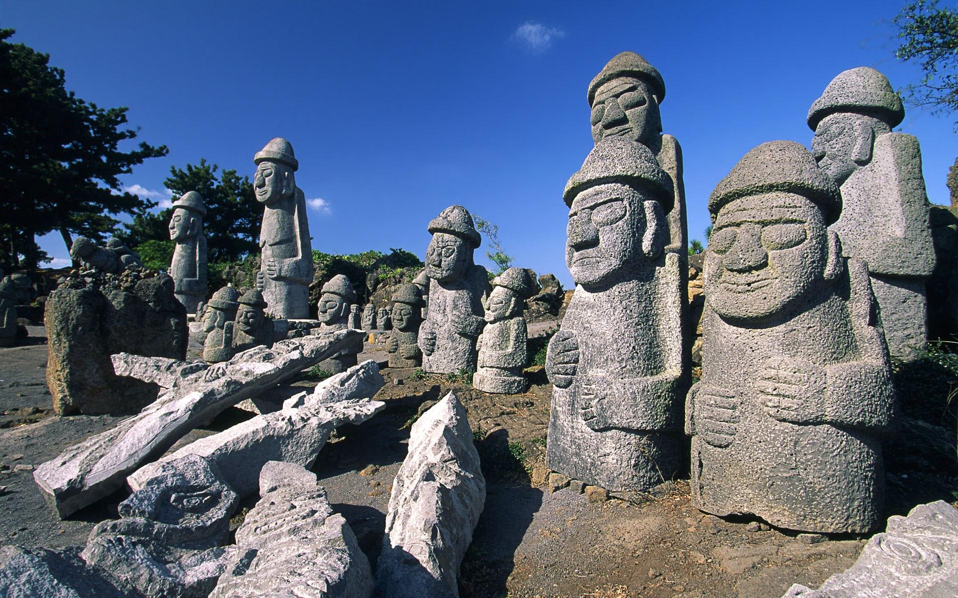
Dol Hareubang statues around the Jeju Island
Image attribution to lt @ Wiki

Getting there :
The nearest airport to Jeju Island is the Jeju International Airport (CJU) and serves international destinations such as China, Japan and Taiwan as well as domestic flights from the mainland.